ENVI Committee Report
If you have any questions or comments regarding the accessibility of this publication, please contact us at accessible@parl.gc.ca.
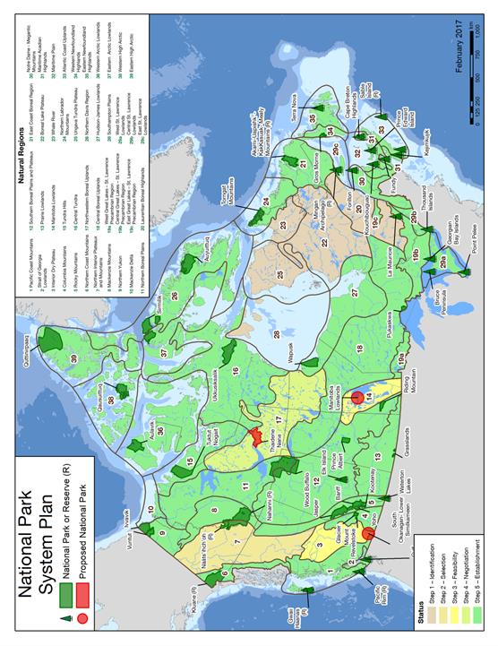
APPENDIX C: STATUS AND GROWTH OF THE NATIONAL PARKS SYSTEM AND THE NATIONAL MARINE CONSERVATION AREAS SYSTEM*
* Provided by Parks Canada, February 21, 2017. GROWTH OF THE SYSTEM OF NATIONAL PARKS OF CANADA (February 2017)
Updated February 16, 2017 Footnotes: 1 In 1904 nine islands were acquired for national park purposes. In 1914, the islands were formally established under legislation as a Dominion Park. In November 2005, the Government of Ontario, Nature Conservancy of Canada and Parks Canada agreed to transfer 10.96 sq. km of mainland to the park. These lands are not yet under the CNPA. In 2013 the name was changed from St. Lawrence Islands National Park to Thousand Islands National Park. Area under the CNPA is 8.3 sq. km. 2 Park area includes the addition of Middle Island, Lake Erie to description in the Schedule to the CNPA (in 2001). 3 Park area: 10.0 sq. km were excised by OIC in 2004, and 10.8 sq. km in 2013 for the purpose of First Nations reserves. 4 Park area: lands were excised by Act of Parliament in 2004 (1.3 sq. km total). 5 Several islands scheduled in the CNPA as part of Georgian Bay Islands NP are managed as part of Fathom Five National Marine Park. The area of the park managed as GBINP is 14 sq. km. The area legislated is 25.6 sq. km. 6 By 1998 federal-provincial agreement, 3.65 sq. km of Greenwich Peninsula lands were transferred to the park. These lands are not yet under the CNPA. 7 Kejimkujik NP Seaside Adjunct added in 1988. 8 Park area reflects inclusions and exclusions to terrestrial and marine areas up to 2006, including lands excised by Act of Parliament in May 2004 for the purpose of a First Nation reserve. 9 Park area reflects legal description in the Park Agreement; park not yet scheduled under the CNPA. 10 Part of Kluane NPR became a National Park through 1993 Champagne and Aishihik First Nation Final Agreement and its 1995 legislation. Kluane First Nation Final Agreement settled in 2003. 11 In 2009, Nahanni National Park Reserve was enlarged from 4,766 sq. km to 30,000 sq. km, making it six times larger. The expansion area was brought under the CNPA on June 18, 2009. 12 Year established: 1) as a NP Reserve, 2) as a National Park. Park area reflects adjustments made pursuant to the 1993 Nunavut Land Claims Agreement. 13 Gros Morne NP was formally established by OIC on October 1, 2005. 14 Park area: land assembly is incomplete, land acquisition is ongoing on a willing seller – willing buyer basis pursuant to the Park Agreement. Total park area identified in the federal-provincial Agreement is 906.4 sq. km. 15 Established as Northern Yukon National Park through the Inuvialuit Final Agreement, the name was changed to Ivvavik National Park of Canada in the CNPA in 2001 16 Year established: 1) as a NP Reserve, 2) as a National Park. Ward Hunt Island is administered by PCA but not yet included in the park’s legal description in the CNPA. 17 Park area: land assembly is incomplete, land acquisition is ongoing on a willing seller – willing buyer basis pursuant to the Park Agreement. Total park area identified in the federal-provincial Agreement is 154.0 sq. km. Not yet scheduled under the CNPA. 18 Legal name in the CNPA is Gwaii Haanas National Park Reserve of Canada. The name in use was officially approved in 2002 by Parks Canada and is listed by the GNBC. (Park name in the Act to be amended.) Park area reflects legal description in the CNPA and the area committed in the Park Agreements (some land with outstanding mining claims not yet added). 19 Land description and park area were included in the Schedule to the CNPA, 2001 with "coming into force" provision - park established by OIC in 2010 when special regulations were brought into force. 20 Agreement signed in 2005 added an expansion of 1,841 sq. km within the Sahtu Settlement Area to the park. These lands are not yet under the CNPA. 21 Gulf Islands NPR land assembly is incomplete, land acquisition is on a willing seller – willing buyer basis pursuant to its 2003 federal-provincial Agreement - as new lands are added, park area will be updated. Park Reserve established through OIC in 2010. 101 hectares were added in 2012, not yet in CNPA. 22 Park area includes the previously Inuit Owned Land parcel RE-32 and excludes the Sila Lodge area. IIBA signed in August 2003, legally established through OIC on 31 July 2014. 23 The Labrador Inuit Park Impacts and Benefits Agreement (PIBA) was signed in 2005 and that same year the CNPA was amended to include Torngat Mountains National Park Reserve. In 2006, the Nunavik Inuit PIBA was signed with Makivik Corp. of Quebec, enabling the park reserve to become Torngat Mountains National Park under the CNPA in 2008. 24 Legally established through amending the CNPA in December 2014, includes boundary adjustment adding 45 sq. km to park (compared with 2012 announcement). 25 Inuit Impact and Benefit Agreement (IIBA) signed January 12, 2015 and effective April 1, 2015. Legislation to add Qausuittuq to CNPA received Royal Assent June 23, 2015 and came into force September 1, 2015. 26 Parks Canada signed a Land Transfer Agreement with the province and a PIBA with the Labrador Innu. Both came into effect July 31, 2015. 27 Administration of the Thaidene Nene lands was transferred to the Government of the Northwest Territories (GNWT) through legislation to implement the devolution agreement, effective April 1, 2014. The land withdrawals in effect were mirrored in GNWT legislation. Parks Canada, GNWT and the Łutsel K’e Dene First Nation agreed to a proposed boundary. Canada announced a 14,000 square km boundary for consultation on July 29, 2015.
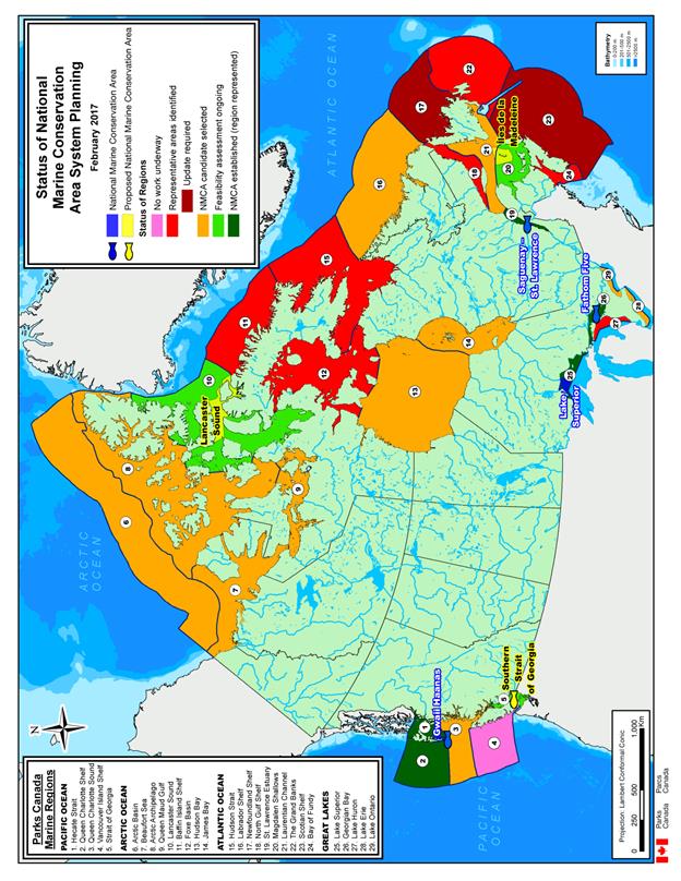
GROWTH OF THE SYSTEM OF NATIONAL MARINE CONSERVATION AREAS OF CANADA
Footnotes: 1 Fathom Five National Marine Park is managed under a 1987 federal-provincial agreement that provided for its establishment as a national marine park (as the areas were called prior to the current NMCA policy and legislation). As described in the federal-provincial agreement, the marine park area includes 98.6 sq km of lakebed area plus a land area of 1.7 sq km (Devil and Echo Islands, and some land base). The total area for Fathom Five given in the table above includes the remaining 19 islands in the marine park, and managed as part of the park, (including Flowerpot Island), totalling 13.24 sq km, which are presently scheduled as part of Georgian Bay Islands National Park in Schedule 1 of the Canada National Parks Act. These 13.24 sq km have been removed from the area provided for Georgian Bay Islands National Park in the national park chart, to prevent double counting. The lake bed and lands have not yet been transferred to the federal government pending resolution of outstanding First Nation issues, as per the federal-provincial agreement. 2 Saguenay-St. Lawrence Marine Park was established under separate legislation, the Saguenay–St. Lawrence Marine Park Act, and is jointly managed with the province of Quebec. In 2007, the Surveyor General’s office of Quebec reported that the size of the marine park in the legal description is inaccurate (it is listed as 1138 sq km). The accurate area is referenced above. The Act will be amended to reflect this new size. 1, 2 These sites are operated and managed as part of the NMCA program, including its policies and guiding principles. 3 The 1987 Canada-British Columbia memorandum of understanding and 1988 agreement respecting Gwaii Haanas provided for the immediate establishment of a national park reserve and the later establishment of a national marine conservation area reserve once certain conditions were met. The 2010 Gwaii Haanas Marine Agreement between the Government of Canada and the Council of the Haida Nation enabled the subsequent Parliamentary process which established the “Gwaii Haanas National Marine Conservation Area Reserve and Haida Heritage Site” under the Canada National Marine Conservation Areas Act, the first in Canada to attain that status. 4 A boundary description was included in the 2015 amendment to the Canada National Marine Conservation Areas Act which confirmed Ontario retains jurisdiction over water taking within NMCAs in the Great Lakes (Royal Assent June 23, 2015). This was a condition precedent in the 2007 federal/provincial agreement for the transfer of the lake bed and lands from Ontario to Canada. Once Ontario transfers the lands, the formal establishment of the NMCA will occur via Order in Council bringing the boundary description into effect. Additional NMCA lands will be added to the Act under a subsequent OIC when Ontario has completed deregulation of the protected areas it is also transferring to Canada as part of the NMCA. Last updated September 2015 |